29th to 31st October 2018 – Postojna, Slovenia
Lidar and ancient pathways: New approaches to detection and modelling of past movement
- pathways and movement
- deep learning from ALS data
- complementary data sources and their integration
- ontologies and knowledge modelling for comparing and integrating case studies
TRAIL Theme
TRAIL IV focuses on the use of lidar data for the study of pathways and movement. The investigation of pathways and movement is crucial to understand the long-term development of landscapes in the past and present. However, the study of ancient pathways and movement is currently approached from various, poorly connected angles. In particular, there is a gap between those who study the past mobility from a socio-theoretical perspective, those who study the material remains of pathways through fieldwork methods and remote sensing; and those studying through computer modelling, the processes that underlie the formation, continuation and abandonment of pathways.
Recently, the detection and identification of ancient pathways has profited enormously from the increased use of lidar-based elevation models. These discoveries, however, are fragmentary and often difficult to date, which makes it challenging to interpret the function and development of ancient communication and transport networks. In order to understand the long-term dynamics of movement and its relation to landscape and settlement development, the information on pathways retrieved through excavation, survey and remote sensing needs to be better integrated with computer models and other spatial data.
During TRAIL IV we will focus on the detection of pathways and movement through lidar surveys, and discuss connections with theories, methods and data used to study pathways and movement through diverse case studies, posing a series of questions. How do we detect paths, itineraries or networks? What kind of paths or networks can be detected using lidar? Can we interpret their chronology or function? What is missing from the lidar data and what is preserved? How can we connect different types of evidence or missing evidence?
We hope that TRAIL IV will contribute to the study of movement and pathways, and will provide an opportunity to form an international network of scholars working on these topics.
Agenda
Monday, October 29th 2018
| 12:00-13:15 | Lunch |
| 13:30-14:00 | Introduction to the meeting and launch of the network |
| 14:00-15:30 | Keynote 1 by Michael Doneus: Evolution of airborne laser scanning in archaeology and future prospects Keynote 2 by Dave Cowley: ‘Because I say so’ – ‘Because the computer says so’: towards accountable knowledge creation in archaeological prospection Invited lecture 1 by Maja Somrak: Introduction to deep learning |
| 15:30-16:30 | Coffee break and poster session |
| 16:30-18:15 | Invited lecture 2 by Philip Verhagen and Laure Nuninger: Introduction to the Movescape project: when studying past movement needs to integrate detection, spatial modeling and theory Invited lecture 3 by Dimitrij Mlekuž: Towards the archaeology of landscape flows Invited lecture 4 by Edisa Lozić: Detection of past movement. The Iron Age Knežak hillfort case study Invited lecture 5 by Catherine Fruchart and Valentin Chevassu: Airborne laser scanning for the study of path networks and field systems |
| 18:15-18:45 | Discussion |
| 19:00-20:00 | Dinner |
Tuesday, October 30th 2018
| 7:00-8:15 | Breakfast |
| 8:45-10:00 | Introductory discussion about workshops |
| 10:00-12:30a | Excursion to Knežak hillfort |
| 10:00-12:30b | Optional visit of the Postojna cave or Karst Museum (entrance fee not covered) |
| 12:30-14:00 | Lunch |
| 14:00-16:00 | Workshop session 1 |
| 16:00-16:30 | Coffee break |
| 16:30-18:30 | Workshop session 2 |
| 19:00-21:00 | International dinner |
Wednesday, October 31st 2018
| 7:00-8:15 | Breakfast |
| 8:45-10:45 | Workshop session 3 |
| 10:45-11:15 | Coffee break |
| 11:15-12:30 | Round table discussion and closing session |
| 12:30-13:30 | Lunch |
Workshops
Airborne laser scanning and deep learning
Clément Laplaige, Dave Cowley, Maja Somrak, Žiga Kokalj
Increasing availability of easy-to-use libraries and software has put forward the use of Machine Learning also in the archaeological exploration of lidar. The aim of this workshop is to see what is required (e.g. algorithms, data quality and homogeneity) to successfully accomplish automatic classification.
Pathways: from practice to evidence of movement in lidar data
Laure Nuninger, Philip Verhagen, Xavier Rodier, Dimitrij Mlekuž
The aim of this workshop is to study the relationship between concepts used in detection and modeling approaches and to build a common conceptual framework. We would like to discuss the interest of such an approach to improve lidar interpretation and compare case studies from around the world.
Integrating lidar and complementary data sources
Rachel Opitz, Catherine Fruchart, Elise Fovet
This workshop focuses on assessing the quality and character of various data types commonly integrated with lidar data in landscape studies. We will consider issues such as scale, resolution, and reliability. We will also discuss ontological and spatial approaches to integration.
Participants will have the opportunity to:
- work with 2D and 3D visualisations of lidar data in an exercise designed to develop a systematic and considered approach to identifying and interpreting the remains of paths as they appear in the topographic data. In this exercise we will consider the possible morphologies of paths, their relationships with other features in the landscape, and the extent to which their likely uses can be assessed.
- practice and discuss the use of historic maps and textual descriptions as complementary sources of information. In this exercise we will focus on managing inaccuracies and uncertainties, and consider the role of historic maps and documents in developing the chronological aspects of the interpretation of paths through the landscape.
Presentations
Evolution of airborne laser scanning in archaeology and future prospects
Michael Doneus
Regardless of whether Airborne Laser Scanning (ALS) is used in open fields, grassland or forested and otherwise densely vegetated areas, it has potential to serve three main aspects of cultural heritage protection: detection, documentation, and monitoring of sites, monuments and landscapes. Since the first TRAIL workshop in 2011, the process chain from data acquisition to the archaeological interpretation is being constantly re-developed and enhanced. Concepts, instrumentation, processing, visualization, but also tools for classification and interpretation are rethought, re-engineered and researched. Current topics include multi-wavelength, underwater, and UAS-based scanning, automated interpretation, deep learning, and the integration with other sources of information and information management. The presentation will give an overview of the state of the art and will specifically deal with some of these latest developments.
‘Because I say so’ – ‘Because the computer says so’: towards accountable knowledge creation in archaeological prospection
Dave Cowley
The talk will draw on documentation of desk-based and fieldwork processes on the island of Arran to ask how we look, how accountable we are, and how deep learning might add an interesting dimension to a process of knowledge creation that is all too often opaque and hidden in the brain of the interpreter.
Introduction to deep learning
Maja Somrak
Aerial archaeology has already started following suit of other scientific disciplines in adopting deep learning, one of the emerging technologies transforming automation. Deep learning is particularly suited to solve complex perception tasks we can’t articulate precisely for a machine to follow. Latest research demonstrates state-of-the-art performance for tasks of image recognition, with accuracy often surpassing that of a human. But is it mostly hype or is deep learning here to stay? As an archaeologist, what should you know about this particular field? The talk will aim to demystify deep learning and offer more insight on this intriguing, novel topic.
Introduction to the Movescape project: when studying past movement needs to integrate detection, spatial modeling and theory
Philip Verhagen and Laure Nuninger
Settlement patterns and path networks evolve with unharmonized temporalities, but in constant interaction which render the territorial studies very challenging. Remote sensing, GIS and 3D modeling have greatly contributed to our knowledge and understanding of movement as encapsulated in routes, but the methods employed make it difficult to connect with theories of engagement through travel. Pragmatically, it is difficult to integrate LiDAR-detected traces of pathways, which conflate temporalities, with network analysis techniques and settlement pattern analysis which focus on changing patterns over time.
After a general review of the main methods developed to detect movement, pathways and networks of transportation, we will present ideas to develop a conceptual framework that will enable us to make the connection between the material evidence of routes and various computer-based models of movement. A comparison of regional case studies from the literature will be presented to discuss the balance between general models and specific contextualisation.
Towards the archaeology of landscape flows
Dimitrij Mlekuž
We live in a material world. The materiality of our existence poses many constraints on our life. We cannot be at two places at the same time, we have very limited ability to undertake more than one task at a time, and everything we do takes time. The materiality of our existence also means that everything we do leaves traces, either on our bodies or upon other bodies. Our life is composed of a stream of tasks that we perform and move from one to another. They move our life on. Life is movement, and one of the fundamental tasks in our life is to move around. Life is woven together by a web of movements. And because movement as a practice is mostly pre-discursive we have enrolled powerful allies which can focus and extend conscious awareness. Movement is not possible without the unmoving, stable things, the infrastructure, various configurations of bodies and things which, knitted together as routinized environments, enable a range of different movements around. That’s why we, people, but also animals, things, and substances do not move around randomly. Movement is not just about individual movement, but about long-term patterns that emerge from routinized movement. These space-time patterns, especially when viewed over very long time, can be described as flows. In this way stable, multiscale spatiotemporal patterns emerge from an intertwined allocation of time among practices in space. Flows move people, animals, things, substances… into new positional and relational contexts with other things and create new material encounters, allowing new and different flows to emerge. Movement is not to be understood as an isolated task but, but instead as a component of a wider pattern of interaction, a “choreography of existence”.
Detection of past movement. The Iron Age Knežak hillfort case study
Edisa Lozić
The area between today’s Ilirska Bistrica and Pivka (Slovenia) has long been known for its numerous Iron Age hillforts. On the 96 km2 of the research area, 11 such settlements are known. Recent analysis of lidar data has revealed high density of archaeological features beyond the hillforts: cairnfields, linear earthworks, field system, enclosures and hollow ways. Most notable are linear boundary earthworks separating the settlements. This data enables us to focus the discussion on the path-network and movement control in this hillfort landscape.
Airborne laser scanning for the study of path networks and field systems
Catherine Fruchart and Valentin Chevassu
ALS data can support detection of unmapped road segments that either correspond to paths of recent origin, or to ancient roads abandoned long ago. Once mapped, they often reveal previously unknown communication networks that we can study at different spatial and temporal scales. These road networks are frequently in relationship with ancient field systems or with settlements or elements in the landscape that testify about a specific past land use. By studying the relationships between these networks and the features they are connected to, we get key information that helps to improve the understanding of landscape dynamics.
We will present several French case studies, focusing on the connections found between road networks, field systems and parts of settlements. We will detail the methods and data used to analyse and contextualize these connections, and compare the results obtained in the different study areas and suggest a hypothesis about possible past land use dynamics.
Excursion
On the excursion the bus will bring you to the foot of the Knežak hill. From there, a gently sloping forest road will take you to the Knežak hillfort and back through the heart of prehistoric landscape. The walk is 100 meters uphill and 2.5 km in total. No special hiking equipment is needed in dry weather, but some form of sportswear is recommended. Hiking boots are highly recommended if weather is wet.
The Knežak hillfort witnessed the peak in habitation, construction and fortification activities during the Iron Age, between the 9th/8th century BC and the arrival of the Romans in the last decades of the 1st century BC. These long centuries of the Iron Age surely bring up numerous questions as to the settlement dynamics, relationships between the hillforts, their hierarchy, evolution, use and function, as well as the development of the wider hillfort landscape.
The preliminary analysis of 96 km2 of lidar data revealed more than 2000 archaeological features. We understand most of them as Iron and Roman Age remains of intensive agricultural use of the landscape. In addition, elements like linear earthwork boundaries in total length of almost 10 km and detail plans of hillforts reflect elements of social structure in the landscape.
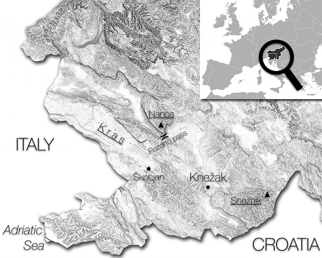
Figure 1. Location of the study area.
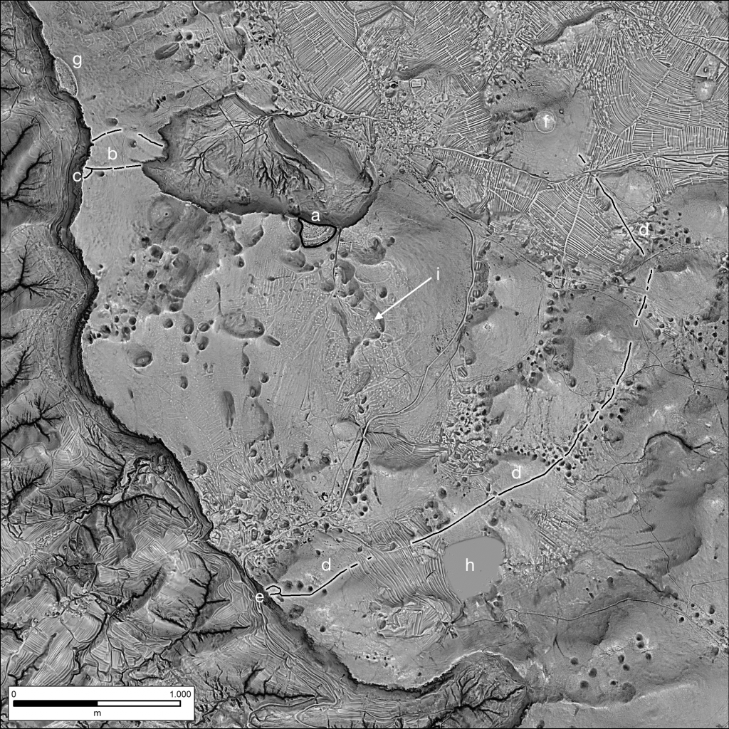
Figure 2. Gradišče above Knežak hillfort (a), linear earthwork boundaries (b – e), Obroba hillfort (f), Gradišče at Čepna hillfort (g) and Šembije intermittent lake (h). Cairn excavated in 1950s and the adjacent location of the 2016 excavation (i). Advanced image fusion visualization, 0.5m DEM.
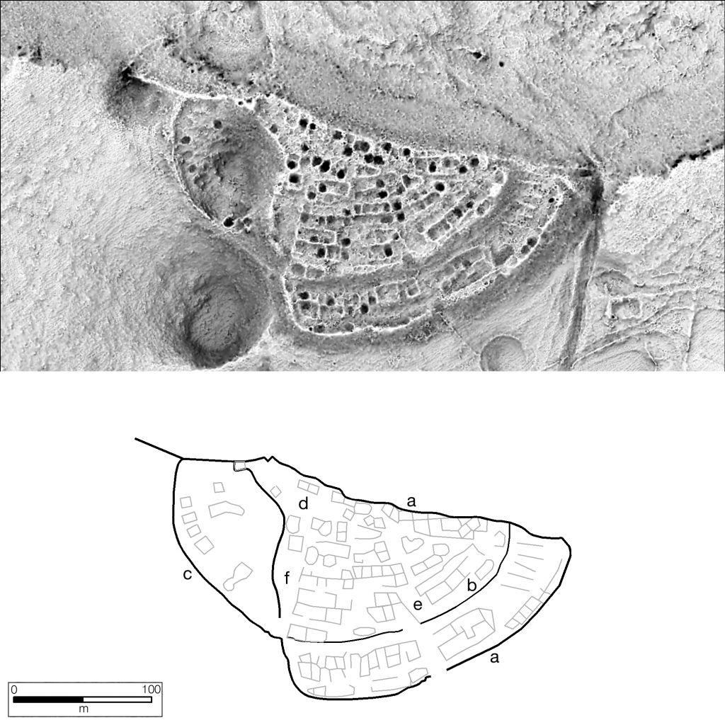
Figure 3. The Gradišče above Knežak hillfort: outer ramparts (a), inner ramparts (b), annex (c) and open square spaces (d – f). Advanced image fusion visualization, 0.5m DEM.
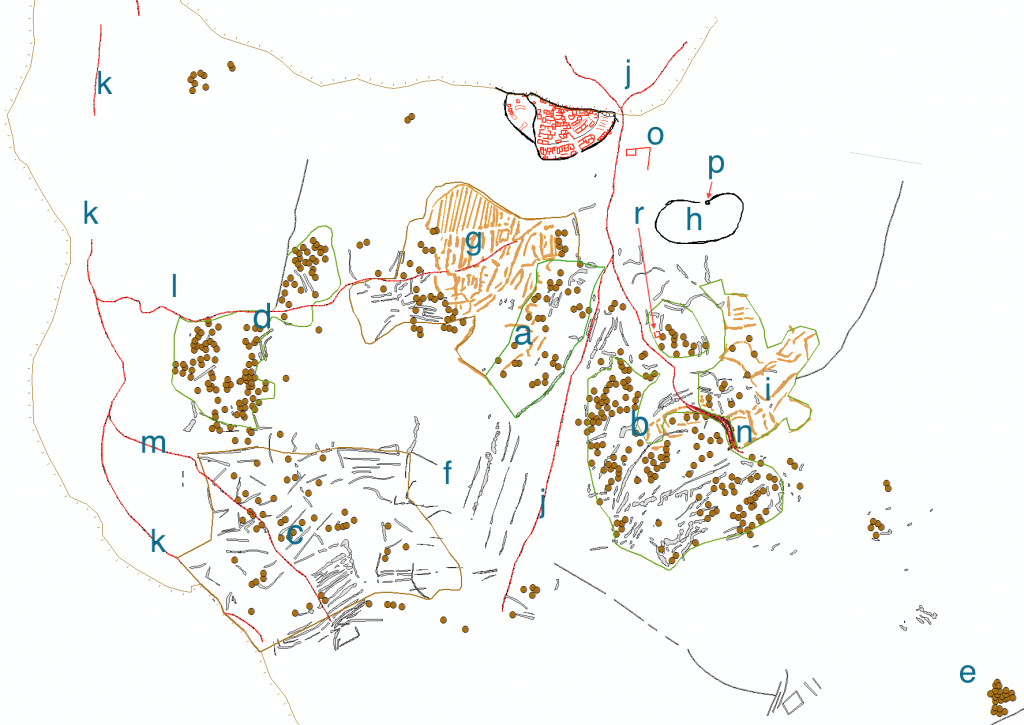
Figure 4. The Gradišče above Knežak hillfort territory: cairnfields (a – e), linear earthworks – possibly terracing (f), field system (g), large enclosure (h), rectangular enclosures (i), hollow ways (j – m) and funnelled way (n).
Organizing committee
- Žiga Kokalj, ZRC SAZU, SPACE-SI, Ljubljana, Slovenia
- Benjamin Štular, ZRC SAZU, Ljubljana, Slovenia
- Laure Nuninger, CNRS, Besançon, France
- Maja Somrak, ZRC SAZU, Ljubljana, Slovenia
- Jasmina Štajdohar, SPACE-SI, Ljubljana, Slovenia
- Edisa Lozić, National museum of Slovenia, Ljubljana, Slovenia
- Jernej Rihter, ZRC SAZU, Ljubljana, Slovenia
- Philip Verhagen, Vrije Universiteit Amsterdam, Amsterdam, The Netherlands
- Rachel Opitz, University of Glasgow, Glasgow, United Kingdom
- Clément Laplaige, Université François-Rabelais de Tours/CNRS, Tours, France
- Xavier Rodier, Université François-Rabelais de Tours/CNRS, Tours, France
- Valentin Chevassu, Université Bourgogne Franche-Comté, Besançon, France
Scientific Committee
- Adnan Kaljanac, University of Sarajevo, Sarajevo, Bosnia and Herzegovina
- Benjamin Štular, ZRC SAZU, Ljubljana, Slovenia
- Clément Laplaige, Université François-Rabelais de Tours/CNRS, Tours, France, Tours, France
- Dave Cowley, Historic Environment Scotland, Edinburgh, United Kingdom
- Dimitrij Mlekuž, University of Ljubljana, Ljubljana, Slovenia
- Elise Fovet, CNRS, Clermont-Ferrand, France
- Ina Miloglav, University of Zagreb, Zagreb, Croatia
- Laure Nuninger, CNRS, Besançon, France
- Máté Stibrányi, Budavári Ingatlanfejlesztő és Üzemeltető Nonprofit Kft., Budapest, Hungary
- Michael Doneus, Ludwig Boltzmann Institute for Archaeological Prospection and Virtual Archaeology, Vienna, Austria
- Philip Verhagen, Vrije Universiteit Amsterdam, Amsterdam, The Netherlands
- Rachel Opitz, University of Glasgow, Glasgow, United Kingdom
- Tatjana Veljanovski, ZRC SAZU, Ljubljana, Slovenia
- Vujadin Ivanišević, Archaeological Institute, Belgrade, Serbia
- Xavier Rodier, Université François-Rabelais de Tours/CNRS, Tours, France, Tours, France
- Žiga Kokalj, ZRC SAZU, SPACE-SI, Ljubljana, Slovenia